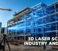
In modern construction and engineering, having accurate information about existing buildings and structures is essential for successful project planning. However, many buildings, industrial facilities, and infrastructure projects in Saudi Arabia have outdated drawings or incomplete documentation that no longer reflects actual site conditions.
3D laser scanning for as-built drawings offers a reliable way to capture existing conditions and convert them into accurate digital documentation. By collecting millions of measurement points from a physical environment, this technology helps architects, engineers, contractors, and facility owners understand the actual dimensions and layout of a structure before beginning renovation, expansion, or modification work.
If you are looking for reliable 3D laser scanning in Saudi Arabia, understanding how laser scanning works and how it supports as-built documentation can help you make informed decisions for your next project.
What Is 3D Laser Scanning for As-Built Drawings?
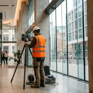
3D laser scanning is an advanced surveying technology used to capture the dimensions, geometry, and spatial details of existing buildings, structures, equipment, and industrial facilities.
A laser scanner collects measurements from surrounding surfaces and generates a detailed digital dataset known as a point cloud. This point cloud represents the actual site conditions and can be processed to create 2D CAD drawings, 3D models, and Building Information Modeling (BIM) deliverables.
As-built drawings document what has actually been constructed rather than what was originally planned in the design drawings. When these drawings are developed using 3D laser scanning data, project teams can work with detailed measurements of existing conditions.
This approach is particularly useful for renovation projects, industrial modifications, facility upgrades, and construction verification where reliable existing-condition information is essential.
Why Are As-Built Drawings Important for Construction Projects in Saudi Arabia?
Saudi Arabia continues to develop commercial buildings, residential communities, industrial facilities, infrastructure, and large-scale construction projects. Across these sectors, accurate site documentation helps project teams plan modifications and coordinate engineering activities more effectively.
Traditional drawings may not reflect changes made during construction, previous renovations, or equipment installations. In these situations, relying only on existing documentation can lead to measurement discrepancies and coordination challenges.
Using 3D laser scanning services in Saudi Arabia helps address these challenges by providing a detailed digital record of the existing environment.
Key benefits include:
- Improved measurement accuracy: Capture detailed dimensions and spatial relationships, subject to the scanning method and project specifications.
- Reduced site measurement effort: Collect large amounts of dimensional data efficiently compared with measuring every feature individually.
- Better renovation planning: Understand existing conditions before modifying a building or facility.
- Improved coordination: Give architects, engineers, and contractors a shared reference for design and construction decisions.
What Does a Laser-Scanned As-Built Drawing Package Include?
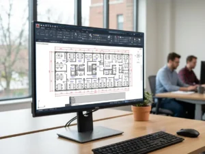
The final deliverables depend on the project scope, required level of detail, and client specifications. A typical laser-scanned as-built documentation package may include the following.
1. 2D As-Built CAD Drawings
Laser scan data can be used to prepare detailed 2D drawings that represent existing site conditions.
Typical drawings include:
- Floor plans and general arrangements
- Building elevations and sections
- Structural layouts and dimensions
- Mechanical, electrical, and plumbing (MEP) layouts, where included in the scanning scope
- Equipment and piping layouts for industrial facilities
- These drawings can be delivered in formats such as DWG and PDF, depending on project requirements.
2. Registered Point Cloud Data
A point cloud is the digital foundation of a laser-scanning project. It contains spatial measurement data captured from the scanned environment and registered into a common coordinate system.
Point cloud deliverables allow design teams to review existing conditions, take measurements, and use the scanned data for further CAD drafting or 3D modeling.
Common delivery formats may include E57, RCP, or other agreed formats compatible with the client’s software.
3. 3D As-Built Models
For projects that require more than 2D drawings, point cloud data can be converted into a three-dimensional model of the existing building, structure, or industrial facility.
These models help project teams visualize spatial relationships, understand complex geometries, and plan modifications with better awareness of existing conditions.
4. Scan-to-BIM Models
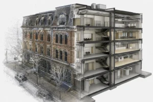
Scan-to-BIM involves converting laser scan data into a Building Information Modeling (BIM) model using software such as Autodesk Revit.
Depending on the project requirements, the model may include architectural elements, structural components, and MEP systems.
Scan-to-BIM is especially valuable for refurbishment, building upgrades, MEP coordination, and ongoing facility management.
5. Existing Condition Verification
Where required, scan data can be compared with design drawings or proposed layouts to identify dimensional differences and potential clashes.
This helps project stakeholders review deviations and make informed decisions before proceeding with construction or installation activities.
3D Laser Scanning Working Process?
Professional 3D laser scanning services generally follow a structured workflow to convert real-world conditions into usable engineering documentation.
Site Assessment and Project Planning
The scanning team reviews the project requirements, site access, areas to be captured, expected accuracy, coordinate requirements, and final deliverables. This stage helps establish the appropriate scanning approach for the building or facility.
On-Site Laser Scanning
A terrestrial laser scanner is positioned at selected locations throughout the site. Multiple scans may be required to capture walls, ceilings, structural elements, equipment, corridors, and other relevant features.
The scanning plan should account for areas hidden from the scanner’s line of sight.
Point Cloud Registration and Processing
Individual scans are aligned and registered into a unified point cloud. The processed dataset is checked for consistency and prepared for drawing production or 3D modeling.
CAD Drafting or BIM Modeling
The registered point cloud is used as a reference to create the required as-built drawings or 3D models. The level of detail depends on the agreed scope and intended use of the deliverables.
Quality Checks and Final Delivery
The completed outputs are reviewed against the project requirements and delivered in the agreed file formats. Any specified dimensional checks, coordinate requirements, or deviation reports are addressed.
How to Choose the Right 3D Laser Scanning Services in Saudi Arabia
Selecting a suitable scanning provider is important for obtaining reliable data and useful engineering deliverables.
Before appointing a provider, consider the following:
- Relevant project experience: Look for experience with buildings, industrial plants, infrastructure, or the type of asset being scanned.
- Scanning equipment and methodology: Ask about the equipment, scanning plan, registration process, and quality-control procedures.
- Defined deliverables: Confirm whether you need point clouds, 2D CAD drawings, 3D models, Scan-to-BIM, or a combination of these.
- Accuracy requirements: Establish the required tolerances and how they will be verified.
- Software compatibility: Ensure the final files work with your team’s CAD, BIM, and engineering software.
- Project coverage: Confirm the provider can access your site and meet the project’s schedule and safety requirements.
- Clear project scope: Request a quotation that specifies the areas to be scanned, modeling detail, file formats, exclusions, and delivery timeline.
Accurate existing-condition data is an important part of successful design, construction, renovation, and facility management. Without a dependable record of the current site, project teams may face unexpected dimensional differences, coordination issues, and avoidable rework.
Professional 3D laser scanning in Saudi Arabia help transform physical spaces into usable digital information. From as-built CAD drawings to detailed point clouds and Scan-to-BIM models, the right solution gives project stakeholders a clearer understanding of existing conditions.
Whether you are planning a building renovation, industrial plant upgrade, MEP modification, or large-scale construction project, laser scanning can provide the dimensional foundation needed for better-informed engineering decisions.
Start Using 3D Laser Scanning for As-Built Drawings
For your upcoming project, are you looking for 3D laser scanning services in Saudi Arabia?
For existing buildings, commercial assets, industrial facilities, and infrastructure projects, our team can assist you in investigating appropriate scanning and documentation options.
Get in touch with us to talk about your project’s location, site specifications, desired deliverables, and expected accuracy. Depending on the scale of your project, we can assist in choosing an appropriate method for generating as-built drawings, point cloud data, or Scan-to-BIM models.