Aerial survey is a method of collecting geomatics or other imagery by using airplanes, helicopters, UAVs, balloons or other aerial methods
- HOME
- ABOUT US
- OUR SERVICES
- LAND SURVEY
- BUILDING SURVEY
- CONSTRUCTION SURVEY SERVICES
- MOBILE MAPPING
- AERIAL / DRONE MAPPING
- UNDERGROUND UTILITY SURVEY
- 3D LASER SCANNING
- METROLOGY SCANNING
- SOIL INVESTIGATION
- BATHYMETRIC SURVEY
- OCEANOGRAPHIC SURVEY
- GEOPHYSICAL SURVEY
- METEOROLOGICAL SURVEY
- MONITORING SOLUTIONS
- DRAINAGE & SEWAGE INSPECTION
- CORING & SCANNING
- OUR TECHNOLOGIES
- CONTACT US
Demarcation Survey
Home > Our Services > Land Survey > Demarcation Survey
Demarcation / Boundary Survey
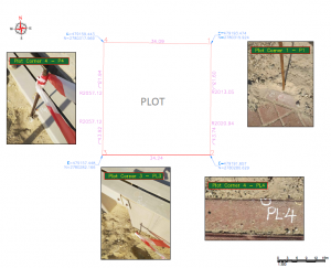
A boundary survey is an important component of pre-construction due diligence. we have large scale of boundary surveyors who make the perimeter of a property as it relates to a site’s legal description.
Falcon Survey have a licensed surveyor to calculate recorded measurement and do a physical inspection to determine the physical boundary of the survey site. A record of survey site will be filed with any relevant consultants as required to help determine if there are any support need on or over the site boundary.
If this is the case, We can provide the expert professional services to resolve these issues by establishing an easement or boundary line agreement.
- Preliminary Demarcations.
- Registration of a Property.
- Boundary dispute resolutions.
- Demarcation of Plot Boundaries for Authorities .
- Initial Demarcation / Redemarcation / Final Demarcations for Trakhees
- Initial Demarcation / Redemarcation Final Demarcations for Nakheel
- Sub-division of Properties
- Setting out of Boundary / Fence for Construction

Frequently Asked Questions
There are often questions you, as a client, may have regarding our surveying services. We have answered the following questions and answers in an attempt to guide you. If, however, you do not find the relevant queries your need in our list below, please get in touch with us.
We always advise knowing exactly where your property lines are before building something as expensive as a wall. It is not only prudent but much less expensive than resolving an encroachment problem through the courts.
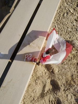
An encroachment is when a structure intrudes on (or over) your land. Some examples of this could be a fence, driveway, or building. Encroachments are some of the more common items encountered when a survey is conducted. Please see the images on the page for some real examples.
When a surveyor finds a material discrepancy between the monuments on the filed plan and their actual physical location, he is required to file a new plan with the authority showing these discrepancies.
As professional surveyors, we believe we provide the most accurate service for our client’s when we calculate your parcels location by starting from the monuments noted on your filed subdivision plan or the Section Monuments set by the Government Land Department. We have no way of knowing if another surveyor’s pins have been accurately set.
That depends of the location and the size of the property. All properties are unique and we will gladly put an estimate together for you.


Related Services
Aerial survey is a method of collecting geomatics or other imagery by using airplanes, helicopters, UAVs, balloons or other aerial methods
A GPR survey involves using a specialized antenna to focus electromagnetic pulses (radar signals) of short duration into the ground
MMS (Mobile Mapping System) is one of the latest surveying technology to measure the object by millions of points per second with centimeter accuracy.
Ready to get started? Let's talk.
If you are in need of a residential land survey, commercial land survey or telecommunication land survey, Falcon Survey is the land surveying firm for your project.
About us
Quick Contact
-
#209, 2nd Floor, Apricot Tower
P.O. Box : 238544, Dubai Silicon Oasis
Dubai - United Arab Emirates
Our Office Saudi Arabia
- Al Akhail, Riyadh - Saudi Arabia
