
Accurate, up-to-date documentation of existing conditions for renovations, retrofits, or quality control.

Any Questions? Let’s talk
+971 4 3271414
Related Services
3D Laser Scanning
FALCON SURVEY
3D Laser Scanning Solutions
One of the rapid compactible industry norm for precision surveying in high accuracy and high worth technical environments now is 3D Laser Scanning. As one of the pioneers in adopting Laser Scanning technology, we are one among the foremost experienced 3D laser scanning services in UAE, Dubai, Abu Dhabi, and Sharjah & Saudi Arabia.
3D laser scanning survey services is a precise method of capturing data in 3D. We will provide rich data with this procedure which allows producing 2D drawings, 3D models, ortho-images and fly-through animations. We offer a unique effort to access a collection of scanners for every project to indulge their individual requirements. 3D laser scanning survey services is often employed in a very wide selection of applications.
To date, we’ve undertaken an extensive range of scanning projects including boats, buildings, statues, streets, petrochemical plants, factories and offices, mines and quarries to tag but a couple of. The biggest challenge on construction projects is having the ability to accurately and quickly collect 3D data. In the design phase, we are able to provide accurate as-built scans of the prevailing conditions. We provide cutting edge 3D laser scanning services that deliver high-accuracy, real-time spatial data for a wide range of industries, including construction, architecture, engineering, manufacturing, and heritage preservation.
Using state of the art laser scanning technology, we generate precise digital representations of physical environments—helping you reduce risk, cut project costs, and streamline decision-making.
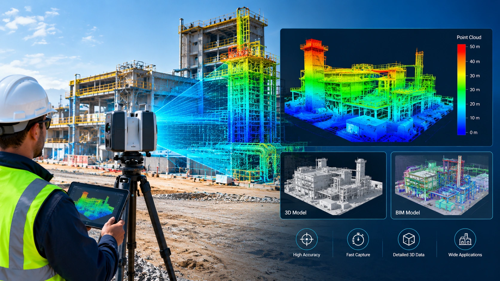
3D laser scanning is a non-contact, non-destructive method of capturing the exact shape and dimensions of objects and environments. Our scanners collect millions of data points per second, producing detailed point clouds that can be used to create:
2D drawings, 3D models (BIM, CAD, Revit), Digital twins, Topographic maps, As-built documentation.
Why Choose Us?
01
High Accuracy & Speed
We deliver millimeter-level precision, reducing the need for rework and site revisits.
02
Experienced Professionals
Our team includes certified surveyors, engineers, and CAD/BIM experts.
03
Flexible Deliverables
Get the data in the format you need: raw point clouds, 2D drawings, 3D models, or GIS files.
04
Nationwide & On-Site Service
Whether it’s a single building or a sprawling industrial site, we come to you.
3D Laser Scanning Services in Saudi Arabia
Falcon Survey provides advanced 3D laser scanning solutions to support construction, architectural, engineering, and industrial projects. Our scanning technology captures detailed site conditions and converts physical spaces, structures, and equipment into accurate digital representations.
For projects in Saudi Arabia, 3D laser scanning can support existing-condition surveys, as-built documentation, renovation planning, industrial facility upgrades, and BIM coordination. The captured point cloud data can be used to develop detailed 2D drawings, 3D CAD models, BIM models, and other project-specific deliverables.
By capturing accurate spatial information, 3D laser scanning helps project teams understand existing conditions, coordinate design work, and make informed engineering decisions.
Looking for 3D Laser Scanning Services in Saudi Arabia?
Contact Falcon Survey to discuss your project requirements, scanning scope, and suitable digital deliverables.
Our 3D Scanning Services Include:
-
As-Built Surveys
-
BIM & CAD ModelingWe convert scan data into intelligent 3D models tailored to your project specifications.
-
Construction VerificationCompare scanned data with design plans to identify discrepancies early and ensure quality.
-
Industrial ScanningComprehensive scanning of complex facilities to assist in maintenance, upgrades, or safety analysis.
-
Heritage & Historical PreservationHigh-resolution 3D documentation of monuments and sites for restoration or virtual archiving.
-
Clash DetectionIdentify and resolve design conflicts before they become costly onsite issues.
3D LASER SCANNING Survey services
Applications for 3D Laser Scanning Survey services will include:
- Remotely capture data from potentially hazardous sites, e.g. motorways or structurally unsafe buildings
- Fast data capture; critical on sites with limited access, e.g. crime scenes
- Complete data collection enables further investigations to be carried out later on without costly returns to the site
- Reduces the costs and downtime associated with construction rework, site revisits and field changes
- Lower cost as-built and topographic survey method compared to alternatives
- Improved accuracy and precision reduces the risks associated with project execution
- Highly-detailed data improves decision-making and engineering designs
- Our professional can enables 3D modelling design and building information modelling (BIM).
FAQ
regular Question for Customer
-
What is 3D laser scanning?3D laser scanning is an advanced surveying technology that captures millions of precise measurements from buildings, structures, industrial facilities, and other objects. Digital models and precise 3D point clouds are produced using the gathered data.
-
Is it possible to employ 3D laser scanning for as-built drawings?Indeed, 3D laser scanning gives measurement data for creating as-built drawings, floor plans, elevations, sections, and 3D models by capturing the current state of a building or structure.
-
What is the duration of a 3D laser scanning project?The project duration depends on the size and complexity of the site, accessibility, required accuracy, and deliverables. Smaller areas may be scanned quickly, while large industrial facilities and infrastructure projects may require more time for scanning and data processing.
-
Do you provide 3D laser scanning services in Dubai and across the UAE?Falcon Survey offers surveying and 3D laser scanning solutions for projects requiring detailed spatial data and digital documentation. Contact our team to discuss your project location, scope, accuracy requirements, and expected deliverables.
-
What is the difference between 3D laser scanning and traditional surveying?Traditional surveying typically measures selected points and features, whereas 3D laser scanning captures a dense collection of measurements across visible surfaces. This provides detailed information about existing conditions and is particularly useful for complex structures and as-built documentation.
Industrial Applications
The petrochemical industry has been using 3D laser scanning for years, but more and more also other industrial sectors see the usefulness of this technique for the management of industrial plants
Volume Calculations
For the determination of the volumetric of stocks 3D laser scanning is used as a reliable and safer alternative to conventional surveying when accuracy is needed.
Infrastructure Applications
Complex structures in field of civil engineering such as bridges and tunnels are measured with a lot of detail with 3D laser scanning.
Architecture Applications
By scanning the facades and interiors of a monumental building a 3D point cloud of the entire building is created. This data serves as the basis for creating floor plans, facade plans, etc.
Archaeological/Heritage
Registration of geometric information of monuments, statues, archaeological remains, etc. makes a major contribution to the preservation of heritage.
Registered Point Cloud
For Clients That Wish to Complete Their Own Post Production We Can Scan and Supply a Registered Point Cloud
3D CAD Models
For Clients That Wish to Complete Their Own Post Production We Can Scan and Supply a Registered Point Cloud
3D Mesh Models
3D mesh models are ideal solution for irregular or organically shaped objects
BIM Models
We can convert the point cloud into a BIM ready format, REVIT, AECOSIM and ARCHCAD models
Plant Design Models
We offer conversion of point clouds into AVEVA PDMS, CADWORX and open plant models
2D CAD Documentation
Highly accurate floor plans, sections & elevations can be generated in a variety of formats and levels of detail which can suit your specific requirements
Orthophotos
We offer Orthophotos – Metric Images Commonly Specified for Heritage Sites
3D Virtual Reality
We can professionally specified the objects, buildings spaces and create game-like environments with interactive 3d walkthroughs.
Panoramic Images
Panoramic images can be supplied referenced to a site map allowing the user to navigate around the site in a product called panotours
Leica TruView
TruView combines panoramic images with point cloud data, allowing the user to take measurements, mark up and share views. It provides an effective visual decision-making tool
Reverse Engineering
Reverse Engineering services help you accurately capture, analyze, and recreate existing components, equipment, structures, and products.
2D/3D Floor Plan
We create accurate and detailed 2D and 3D floor plans that help architects, engineers, contractors, property owners, and real estate professionals understand spaces clearly
Sectional Drawings
We create accurate and detailed sectional drawings that provide a clear view of building elements, levels, heights, materials, and construction details.
Facade/Elevation Building Survey
Our Facade & Elevation Building Survey services provide accurate documentation of a building’s external appearance, dimensions, architectural features.
Measured Building Surveys
Our Measured Building Survey services provide precise measurements and detailed documentation of existing buildings and spaces. We capture the actual dimensions,.
Concrete Scanning(Post Tension)
Post-tensioned concrete structures contain high-strength steel tendons embedded within the slab. Drilling, coring, cutting, or anchoring without knowing their exact location.
Stockpile Survey
Stockpile surveying provides accurate measurements of material volume, quantity, and distribution for aggregates, sand, gravel, soil, minerals, and other bulk materials.

FALCON SURVEY ENGINEERING CONSULTANTS is a pioneering Survey Engineering Company in U.A.E. established in the year of 2007, Falcon Survey Engineering built on a strong work ethic, honesty and a commitment to relationships.
Contact Info
- 209, 2nd Floor, Apricot Tower P.O. Box : 238544, Dubai Silicon Oasis Dubai - United Arab Emirates
- info@falconsurveyme.com
- +971 4 327 1414
- +971 4 327 1413
- Monday - Saturday: 08.00 AM to 06.00 PM | Sunday is Closed
Social Links