
Geophysical / Seabed Mapping Surveys
A small river named Duden flows by their place and supplies it with the necessary regelialia. It is a paradise
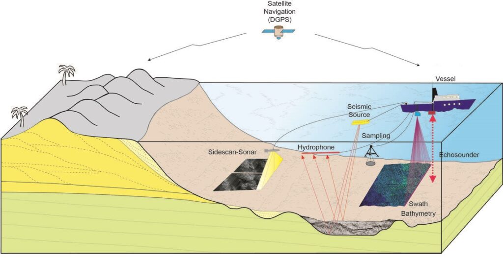
Seabed Mapping Surveys
Marine Survey is related with the production of maps and charts of the seabed and the geological structure down it.
This mapping is conducted using a variety of instruments operated from coastal and ocean-going vessels. Echo sounders are used to determine water depth and hence seabed topography or bathymetry.
Are you looking for Survey
Ready to get started? Let's talk.
If you are in need of a residential land survey, commercial land survey or telecommunication land survey, Falcon Survey is the land surveying firm for your project.
About us
Falcon Survey Engineering Consultants is a pioneering Survey Engineering Company in UAE
established in the  year of 2007, built on a strong work ethic, honesty and commitment to
relationships. Today Falcon is one of the leading organizations in the field of Land Surveying,Soil Investigation,Ariel Survey
(UAV/Drone Mapping),Bathymetric Survey
(Hydrographic),Underground Surveying,3D Laser Scanning Surveying,Calibration Services,
Material Testing as well as Geographic Surveys which has International Standard and Quality
Quick Contact
-
#209, 2nd Floor, Apricot Tower
P.O. Box : 238544, Dubai Silicon Oasis
Dubai - United Arab Emirates