
Calculate the volume of sand, gravel, aggregates, coal, and other stored bulk materials.

Any Questions? Let’s talk
+971 4 3271414
Related Services
Volume Calculations
Bathymetric SURVEY
Volume Calculations
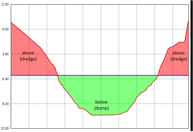
Different authorities need to undertake routine or periodic dredging of their berths, channels and reclamation areas to be sure of the continued safe navigation of maritime traffic. Dredging surveys activities are a critical component of this safety function and should performed to a high degree of horizontal and vertical accuracy
We have qualified and experienced team to do the high order surveys for dredging programs. We can precisely calculate the estimated volumes and dredged volumes.
3D Laser Scanning for Volume Calculation
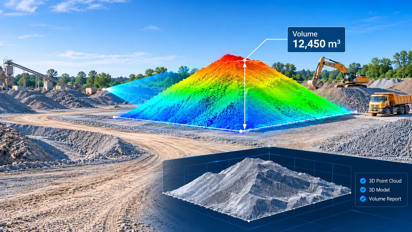
Accurate volume measurement plays an important role in construction, mining, quarrying, and industrial operations. Falcon Survey uses advanced 3D laser scanning technology to capture detailed surface information and calculate material volumes with greater accuracy and consistency.
By collecting millions of spatial data points, 3D laser scanning creates a detailed representation of the surveyed area. This data helps determine the volume of stockpiled materials, excavated soil, aggregates, and other bulk materials. Our scanning-based approach provides reliable digital measurements that support material management, quantity assessment, and project planning.
How 3D Laser Scanning Measures Volume
3D laser scanning measures volume by capturing the surface geometry of an area using laser technology. The scanner records millions of measurement points, which are processed into a detailed 3D point cloud.
The captured point cloud is then cleaned, registered, and analyzed to generate a digital surface model. By defining a suitable reference surface or base level, the volume of the surveyed material can be calculated using specialised processing software.
This method provides a detailed understanding of irregular surfaces and complex material formations that may be difficult to measure using conventional methods.
Applications of Volume Calculation
3D laser scanning-based volume calculation is useful across several industries where accurate material quantity assessment is required.
-
Stockpile Volume Measurement
-
Excavation Volume CalculationMeasure excavated soil and earthwork quantities by comparing existing and reference ground surfaces
-
Mining and Quarry SurveysAssess extracted materials and stockpile quantities for operational planning and inventory management.
-
Construction ProjectsDetermine material quantities and monitor changes in site conditions during different construction stages.
-
Industrial Material ManagementMeasure bulk material deposits and support quantity assessment within industrial facilities.
Volume Calculation Deliverables
Based on project scope and client requirements, Falcon Survey can provide the following deliverables:
- Registered and processed 3D point cloud data
- 3D surface models
- Stockpile volume reports
- Excavation and earthwork volume calculations
- Material quantity assessment reports
- Digital survey data for engineering and project documentation
Industrial Applications
The petrochemical industry has been using 3D laser scanning for years, but more and more also other industrial sectors see the usefulness of this technique for the management of industrial plants
Infrastructure Applications
Complex structures in field of civil engineering such as bridges and tunnels are measured with a lot of detail with 3D laser scanning.
Architecture Applications
By scanning the facades and interiors of a monumental building a 3D point cloud of the entire building is created. This data serves as the basis for creating floor plans, facade plans, etc.
Archaeological/Heritage
Registration of geometric information of monuments, statues, archaeological remains, etc. makes a major contribution to the preservation of heritage.
Registered Point Cloud
For Clients That Wish to Complete Their Own Post Production We Can Scan and Supply a Registered Point Cloud
3D CAD Models
For Clients That Wish to Complete Their Own Post Production We Can Scan and Supply a Registered Point Cloud
3D Mesh Models
3D mesh models are ideal solution for irregular or organically shaped objects
BIM Models
We can convert the point cloud into a BIM ready format, REVIT, AECOSIM and ARCHCAD models
Plant Design Models
We offer conversion of point clouds into AVEVA PDMS, CADWORX and open plant models
2D CAD Documentation
Highly accurate floor plans, sections & elevations can be generated in a variety of formats and levels of detail which can suit your specific requirements
Orthophotos
We offer Orthophotos – Metric Images Commonly Specified for Heritage Sites
3D Virtual Reality
We can professionally specified the objects, buildings spaces and create game-like environments with interactive 3d walkthroughs.
Panoramic Images
Panoramic images can be supplied referenced to a site map allowing the user to navigate around the site in a product called panotours
Leica TruView
TruView combines panoramic images with point cloud data, allowing the user to take measurements, mark up and share views. It provides an effective visual decision-making tool
Reverse Engineering
Reverse Engineering services help you accurately capture, analyze, and recreate existing components, equipment, structures, and products.
2D/3D Floor Plan
We create accurate and detailed 2D and 3D floor plans that help architects, engineers, contractors, property owners, and real estate professionals understand spaces clearly
Sectional Drawings
We create accurate and detailed sectional drawings that provide a clear view of building elements, levels, heights, materials, and construction details.
Facade/Elevation Building Survey
Our Facade & Elevation Building Survey services provide accurate documentation of a building’s external appearance, dimensions, architectural features.
Measured Building Surveys
Our Measured Building Survey services provide precise measurements and detailed documentation of existing buildings and spaces. We capture the actual dimensions,.
Concrete Scanning(Post Tension)
Post-tensioned concrete structures contain high-strength steel tendons embedded within the slab. Drilling, coring, cutting, or anchoring without knowing their exact location.
Stockpile Survey
Stockpile surveying provides accurate measurements of material volume, quantity, and distribution for aggregates, sand, gravel, soil, minerals, and other bulk materials.
Ready to get started? Let's talk.
If you are in need of a residential land survey, commercial land survey or telecommunication land survey, Falcon Survey is the land surveying firm for your project.

FALCON SURVEY ENGINEERING CONSULTANTS is a pioneering Survey Engineering Company in U.A.E. established in the year of 2007, Falcon Survey Engineering built on a strong work ethic, honesty and a commitment to relationships.
Contact Info
- 209, 2nd Floor, Apricot Tower P.O. Box : 238544, Dubai Silicon Oasis Dubai - United Arab Emirates
- info@falconsurveyme.com
- +971 4 327 1414
- +971 4 327 1413
- Monday - Saturday: 08.00 AM to 06.00 PM | Sunday is Closed
Social Links