

Any Questions? Let’s talk
+971 4 3271414
Related Services
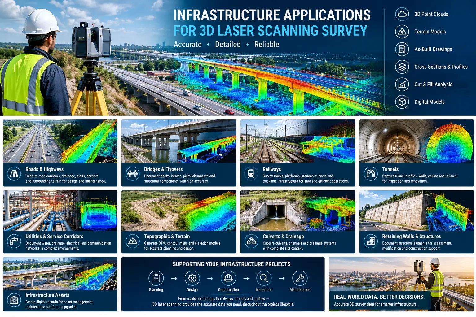
Applications of 3D Laser Scanning in Infrastructure
Using advanced laser scanning technology, millions of measurement points can be collected to create detailed 3D point clouds, terrain models, structural documentation, as-built drawings, sections, elevations, and digital models.
Our infrastructure 3D laser scanning services support the planning, design, construction, inspection, monitoring, and maintenance of roads, bridges, railways, tunnels, utilities, and other civil infrastructure projects.
Accurate 3D Data for Infrastructure Projects
Infrastructure environments can be large, complex, and difficult to measure using conventional surveying methods. Existing roads, bridges, structures, utilities, drainage systems, and terrain often contain numerous details that need to be documented accurately.
3D laser scanning captures the physical environment as a dense three-dimensional point cloud, providing detailed information that can be used by surveyors, engineers, architects, contractors, and infrastructure consultants.
Our surveys can capture:
- Roads & Highways
- Bridges & Flyovers
- Railways
- Tunnels
- Utility & Service Corridors
- Topographic &Terrain Surveys
- As-built documentation
- Construction Progress Monitoring
- Cut & Fill Analysis
- Infrastructure Asset Management
Roads & Highways
Capture detailed road corridors, terrain, drainage, kerbs, barriers, and surrounding features for planning, design, rehabilitation, and maintenance.
Bridges & Flyovers
Create accurate 3D records of decks, piers, beams, abutments, and structural components for inspection, assessment, and renovation.
Railways
Survey railway tracks, platforms, stations, bridges, tunnels, and trackside infrastructure for upgrades, design, and clearance analysis.
Tunnels
Capture tunnel walls, ceilings, floors, profiles, utilities, and structural elements for inspection, documentation, and maintenance.
Utilities & Service Corridors
Document visible pipelines, drainage, electrical systems, communication infrastructure, and utility structures for design and coordination.
Topographic & Terrain Surveys
Generate detailed 3D terrain models, contours, elevations, profiles, and cross-sections to support infrastructure planning and earthwork.
Culverts & Drainage
Capture drainage channels, culverts, structures, and surrounding terrain to support design, inspection, and maintenance projects.
Retaining Walls & Structures
Document existing structural geometry for assessment, modification, rehabilitation, and construction planning.
As-Built Documentation
Create accurate digital records of completed infrastructure, providing reliable data for future maintenance, upgrades, and facility management.
Construction Progress Monitoring
Compare scans from different project stages to monitor construction progress, surface changes, quantities, and completed work.
Cut & Fill Analysis
Compare existing and design surfaces to calculate excavation, embankment, cut, fill, and other earthwork quantities.
Infrastructure Asset Management
Develop detailed digital records of infrastructure assets to support maintenance planning, future design, inspections, and upgrades.
Reliable 3D Survey Data for Infrastructure
Infrastructure projects depend on accurate information about existing conditions. 3D laser scanning surveys provide detailed spatial data that can help engineers, contractors, surveyors, and project managers understand complex environments and make informed project decisions.
From roads and bridges to railway corridors, tunnels, utilities, and large-scale infrastructure developments, 3D laser scanning offers an efficient approach to capturing existing conditions and producing detailed digital survey information.
Industrial Applications
Volume Calculations
Architecture Applications
Archaeological/Heritage
Registered Point Cloud
3D CAD Models
3D Mesh Models
BIM Models
Plant Design Models
2D CAD Documentation
Orthophotos
3D Virtual Reality
Panoramic Images
Leica TruView
Reverse Engineering
2D/3D Floor Plan
Sectional Drawings
Facade/Elevation Building Survey
Measured Building Surveys
Concrete Scanning(Post Tension)
Stockpile Survey

Contact Info
- 209, 2nd Floor, Apricot Tower P.O. Box : 238544, Dubai Silicon Oasis Dubai - United Arab Emirates
- info@falconsurveyme.com
- +971 4 327 1414
- +971 4 327 1413
- Monday - Saturday: 08.00 AM to 06.00 PM | Sunday is Closed
Social Links