

Any Questions? Let’s talk
+971 4 3271414
Related Services
High-Precision Orthophoto Mapping Services
Orthophotos
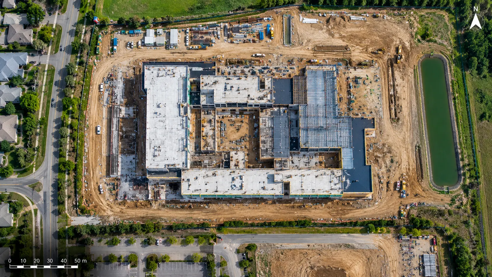
An orthophoto, also known as an orthograph, is a photographic depiction of the Earth’s surface that is free of geometric errors, uniformly scaled, and shows every feature in orthogonal projection. An orthophoto blends the visual detail of a photograph with the metric characteristics of a map, in contrast to a traditional aerial photograph that displays distortions brought about by camera perspective, sensor tilt, and terrain relief.
Why Are Orthophotos Used?
Orthophotos provide a clear aerial view of a site while retaining useful spatial information. They can be used as a background for CAD, GIS, surveying, planning, and engineering work.
Common uses include:
- Site Mapping – Create detailed aerial maps of construction sites, land parcels, and developments.
- Topographic Survey Support – Use orthophotos alongside elevation and survey data.
- Construction Monitoring – Compare site conditions and construction progress over time.
- Land Development Planning – Understand existing site features before development.
- Road & Infrastructure Mapping – Document roads, drainage, utilities, and surrounding areas.
- Agricultural Mapping – Monitor fields, vegetation, irrigation, and land conditions.
- Quarry & Mining Surveys – Map stockpiles, excavation areas, and site conditions.
- GIS Mapping – Integrate aerial imagery into GIS and spatial data workflows.
- Environmental Studies – Document vegetation, water bodies, terrain, and land-use conditions.
Our Orthophoto Mapping Process
1. Site Planning
We plan the aerial survey based on project area, required coverage, ground conditions, and mapping requirements.
2. Aerial Image Capture
High-resolution images are captured using suitable UAV/drone photogrammetry equipment.
3. Ground Control
Ground control points and survey information can be used to improve the positional accuracy of the final mapping.
4. Image Processing
Captured images are aligned and processed using photogrammetric workflows.
5. Orthorectification
The imagery is corrected for perspective, terrain, and other distortions.
6. Orthophoto Generation
The processed images are combined to create a seamless, high-resolution orthophoto.
7. Quality Check & Delivery
The final output is reviewed and delivered in the required format and coordinate system.
Orthophoto Applications
Construction & Engineering
Monitor site conditions, earthworks, roads, structures, and construction progress.
Land & Property Surveys
Create detailed aerial documentation of land parcels and developed areas.
Infrastructure
Map roads, bridges, drainage networks, utility corridors, and other infrastructure.
Mining & Quarrying
Document excavation areas, stockpiles, haul roads, and changing site conditions.
Agriculture
Map agricultural areas and monitor land, crops, irrigation, and drainage features.
Urban Planning
Provide aerial information for development planning, infrastructure studies, and site analysis.
Environmental Mapping
Document natural features, vegetation, water bodies, and land-use changes.
For projects that need in-depth site details, orthophotos can be seamlessly integrated with topographic surveys, 3D laser scanning, drone photogrammetry, point clouds, DTM, and CAD data.
This combination delivers a thorough digital representation of the project area, enhancing planning, design, construction, and documentation efforts.
Industrial Applications
Volume Calculations
Infrastructure Applications
Architecture Applications
Archaeological/Heritage
Registered Point Cloud
3D CAD Models
3D Mesh Models
BIM Models
Plant Design Models
2D CAD Documentation
Orthophotos
3D Virtual Reality
Panoramic Images
Leica TruView
Reverse Engineering
2D/3D Floor Plan
Sectional Drawings
Facade/Elevation Building Survey
Measured Building Surveys
Concrete Scanning(Post Tension)
Stockpile Survey

Contact Info
- 209, 2nd Floor, Apricot Tower P.O. Box : 238544, Dubai Silicon Oasis Dubai - United Arab Emirates
- info@falconsurveyme.com
- +971 4 327 1414
- +971 4 327 1413
- Monday - Saturday: 08.00 AM to 06.00 PM | Sunday is Closed
Social Links